Glory Hole Falls
Up at 5:00 a.m. so I could get to the Buffalo River region early last Saturday. I had the short trail to Glory Hole Falls all to myself. It was a special time since this trail is usually covered up with people on the weekends.
As I hiked away from the falls, I passed twenty hikers heading down the trail. I was thankful for my early morning time with this special little spot in the Ozarks.
Glory Hole Falls up close.
Hiker on Goat Bluff looking down on the Buffalo River
Later in the day I enjoyed some larger views. This wonderful fourteen-mile day was only possible because I chose to be an early bird hiker and waterfall watcher.
In response to The Daily Post’s weekly photo challenge: “Early Bird.”
Tag Archives: Arkansas waterfall


Beauty in Our Own Back Yard – The Lake Alma Trail

Area photographer at McWater Falls
Here’s a link to my article in the April issue of Entertainment Fort Smith. I’m pleased to share the Lake Alma Trail with the readers of Entertainment Fort Smith. Wouldn’t you know Hiker-dog made it into the article’s slideshow. Hope her ego doesn’t get out of hand.
Beauty in Our Own Back Yard – The Lake Alma Trail
http://www.efortsmith.com/features/index.cfm/Beauty-in-Our-Own-Backyard-Lake-Alma-Trail/-/aid/200/
Haiku in the Ozarks
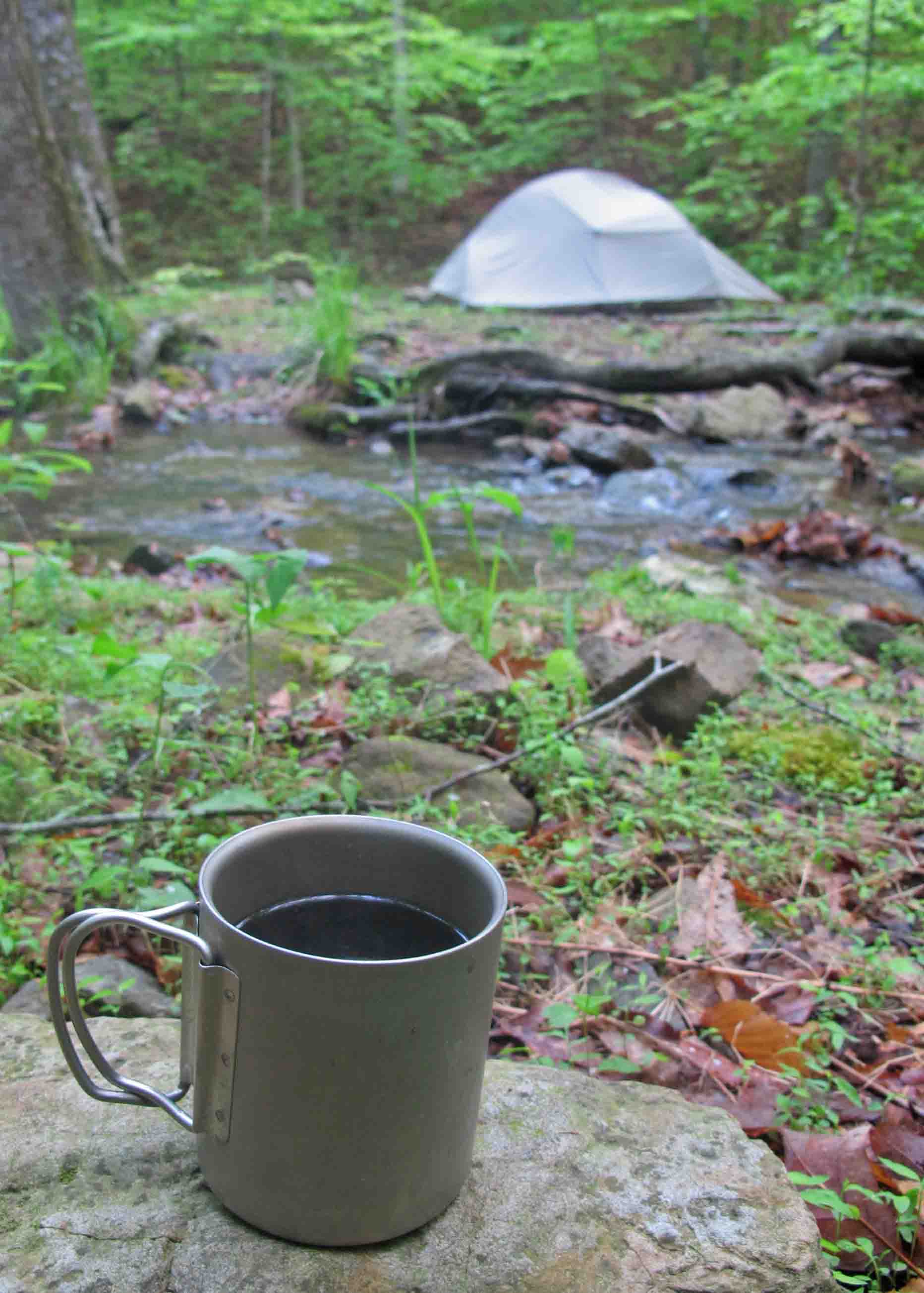
Five-star hotel and gourmet coffee next to Briar Branch
“TJ’s Household Haiku Challenge”
Black coffee on stone.
Table set for the day in
My five-star hotel.
This cup travels with me always, a favorite outdoor household item. On this cold morning, sitting next to Briar Branch in the Marinoni Scenic Area on the Ozark Highlands Trail, I felt intense thankfulness. I was thankful for the morning, the water, the coffee, and the strength that brought me there. How could I want for anything more while enjoying these five-star accommodations?

Redding Loop Trail waterfall
Hard rains have fallen.
Waterfalls flow milky white.
Sit silent and drink.
This extra Haiku came as I thought about last week’s waterfalls. No household item here unless we allow my camera to qualify. It sits in a prominent location in my home, always charged and ready for the trail.
Lake Alma Trail: kid friendly out-and-back day hike

McWater Falls (photo J. Warnock)
Trail description and photos: Jim Warnock
At a Glance
GPS: N35 29.818 W94 13.073
Distance and Configuration: 2.6-mile out-and-back
Hiking Time: 2 hours (approximate)
Highlights: Lake views, waterfall, and beautiful creeks.
Facilities: restrooms and picnic area
Wheelchair Access: no
Dogs: yes
Comments: The 1.6-mile out-and-back to McWater Falls is an easier option for those wanting a shorter hike.
Contacts: facebook.com/LakeAlmaTrail Email: hmcwater@windstream.net Blog: ozarkmountainhiker.com
Overview
If you’re a parent looking for an easy day hike to introduce your children to the gentle pleasures of nature or a trail runner looking for a heart-throbbing but pleasant path, this out-and-back hike is for you!
Chuck Dovish, of Exploring Arkansas with AETN, said, “It’s amazing that so much variety and diversity of scenery is found right inside the town of Alma.” You’ll see bluff lines and moss-covered boulder fields up close. You’ll walk beside clear streams, rocky cascades and a 12-foot waterfall. Situated within a diverse mixed hardwood forest, you may spot deer, rabbit, fox, great blue heron, and a variety of songbirds and wildflowers.
The Hike
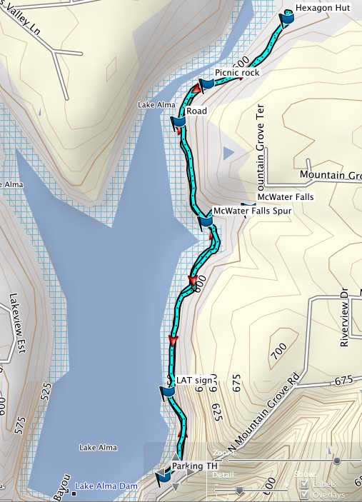
We’ll be accessing the Lake Alma Trial by the paved walking path that connects to the parking area. As you begin walking you’ll see another paved path down below and closer to the lake on your left. Note: There are mile markers on this trail, but they are approximate and based on distances calculated from the kiosk. Our mileage will be calculated beginning and ending at the parking area, making the mile markers on the trail shorter than our actual distance.
At mile 0.2, you’ll arrive at the Lake Alma Trail kiosk. Stop and have a look at the map and check for updates on trail conditions. This is where the pavement ends, and the work of volunteers begins. The kiosk was built and installed by volunteers. The trail logo was created by a young community volunteer. The tread on which you walk was cut out, and continues to be maintained, by volunteers.
The first section of the trail is easy walking. At mile 0.5, the trail turns to the right and goes up to cross a small drainage. More easy walking until you arrive at the first bridge. The trail follows around the base of a hillside and then crosses a second bridge. If water is flowing under this bridge, the waterfall is flowing and definitely worth seeing.
Take a right on the McWater Falls spur trail, arriving at the falls at mile 0.8. This is a nice out-and-back for children and novice hikers and provides a 1.6-mile hike. If you have young children, consider this option and take your time returning to the trailhead.
This waterfall is named for Harry McWater, the man who had the vision for this trail. During the late 1990s as a member of the Alma City Council, Harry brought up the possibility of a trail around the lake several times only to be told that money for such a project wasn’t available. In 2011, during a conversation with the mayor he asked, “What if I find volunteers to get that hiking trail built?” The mayor said, “Go for it!”
With that, Harry sought expertise and labor from the Arkansas Master Naturalists, Ozark Highlands Trail Association, Fort Smith Trailblazers, and local volunteers, including student organizations and scout troops. The trail began to see regular use in the spring of 2012 and its popularity has continued to grow.
Now, back on the trail. After enjoying McWater Falls, backtrack one-tenth of a mile to the main trail and turn right. You’ll get glimpses of the lake in the distance on your left. At mile 1.0, you’ll turn right onto an old roadbed. Watch to your right for some nice bluff areas and rock formations as you walk this section. At 1.3-miles, you’ll pass moss and lichen covered boulders that appear to have tumbled down the hillside on your right. Just past the 1-mile marker you’ll come to the Hexagon Hut. This homesite is a great place to explore. Please leave any historical artifacts in place. Mystery surrounds the construction of these structures and their occupants.

Hexagon Hut
At this point, you’ve actually hiked 1.4 miles from the parking lot and including the waterfall spur. This is where we’ll turn around and return to the trailhead for a 2.6-mile hike. Sometimes the best part of a hike is the backtracking portion. You’ll often notice views missed on the first trip through.
Note: The Lake Alma Trail does loop all the way around the lake, returning to the trailhead by way of the dam, but this is a 4.5-mile strenuous hike. There are some very rocky and difficult sections beyond the Little Frog Bayou crossing. Only experienced hikers with water and sturdy shoes should consider doing the whole loop trail around Lake Alma.
Directions
Take Exit 13 off of I-40 and drive north to the first traffic light. Turn right (east) onto Collum Lane East. Drive 0.2 mile and then left (north) on Mountain Grove Road. Drive north on Mt. Grove Road for 0.3 mile and take a left just past the two green water tanks. Drive down to the picnic area parking. The Lake Alma Trailhead is at the opening in the parking guardrail.

Logo design by Ashley Campbell

McWater Falls – Lake Alma Waterfall
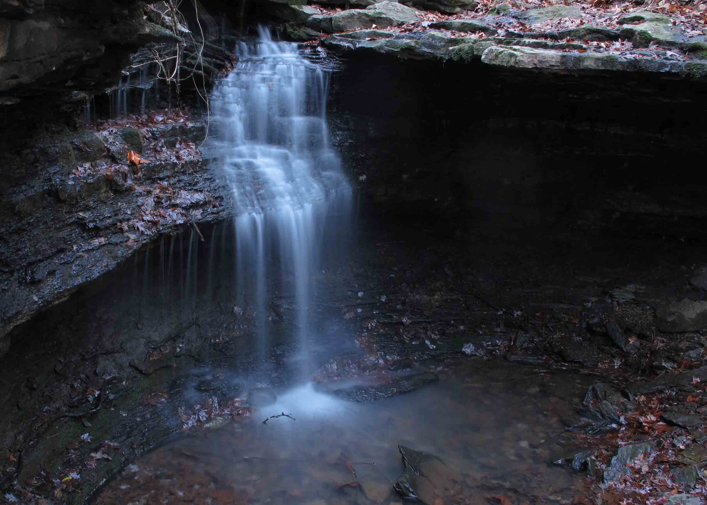
McWater Falls as viewed from the trail.
Every little lake should have its own little waterfall and so it is that we have Lake Alma Waterfall, a short distance from the trailhead of Lake Alma Trail. We’ve been longing for some rain, not only because water levels are low, but because the creeks around Lake Alma and the Ozarks have been pretty dry. With recent rain, we’re finally able to see the Lake Alma Waterfall (Update as of April, 2013: The Alma City Council designated McWater Falls in recognition of Harry McWater who was instrumental in the construction of the Lake Alma Trail).
At approximately 12-feet tall this is definitely worth checking out. The shape, location, and pretty little drainage make this a great place to spend some time. Give yourself an hour or more so you can sit and enjoy the sight and sound.
Read my blog about the Lake Alma Trail for directions on how to get there. The spur trail to this waterfall is only a 25-minute walk from the trailhead. The spur is about one tenth of a mile long.
Get out and enjoy!
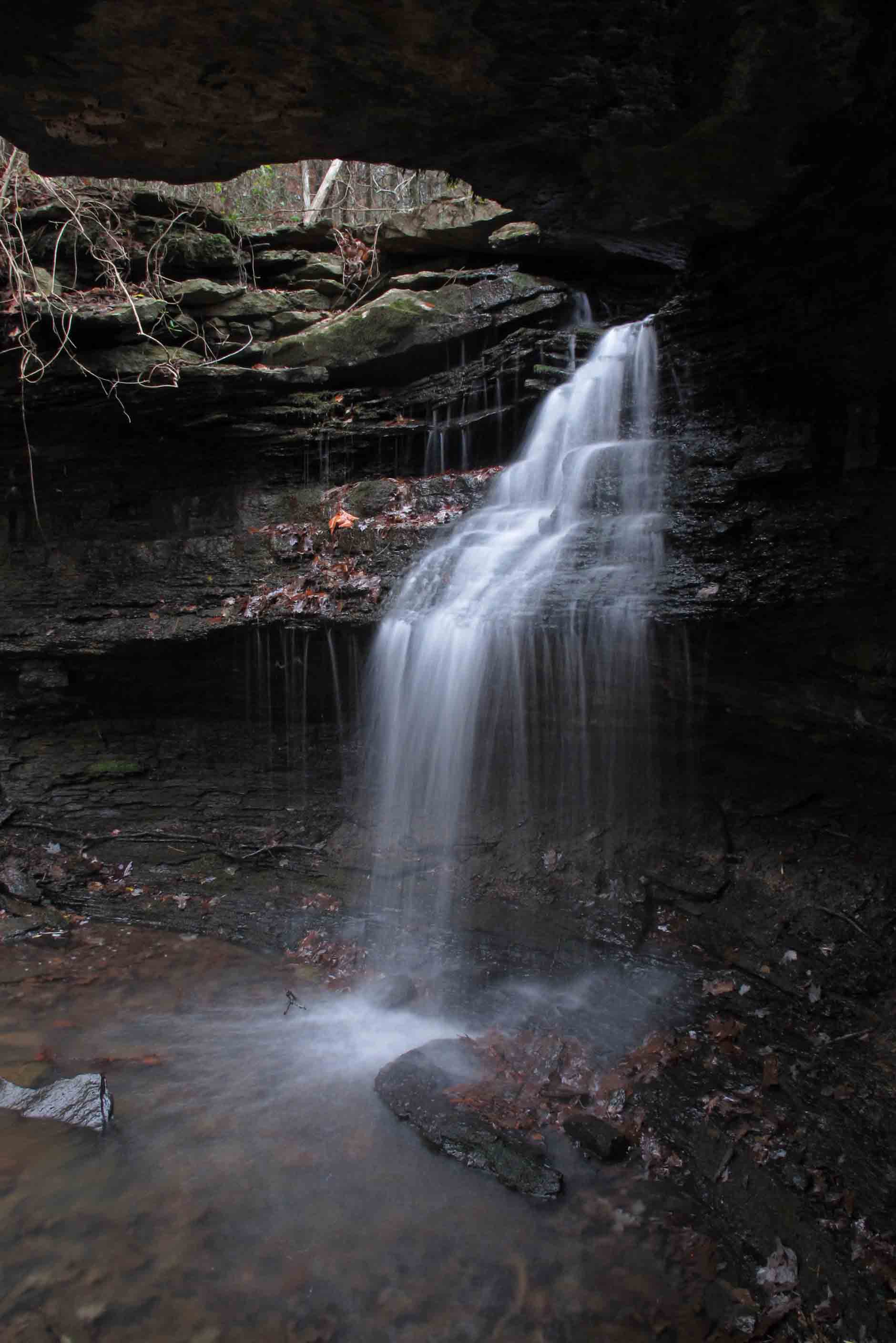
McWater Falls as viewed from underneath its bluff.

McWater Falls is located in a beautiful drainage .1 of a mile off the main trail.
This next picture is of poor quality but it gives a perspective on the size of the waterfall.


Lake Alma Trail Waterfall, McWater Falls
