It had been too many years since my last hike on the Sylamore Creek Trail. An early backpacking memory is hiking about three miles out on the Sylamore Creek Trail from Blanchard Springs and spending the night next to the creek.
This time I wanted to cover more trail miles and see it all from both directions as a long day hike. A friend from the area recommended I visit Gunner Pool which is just over 5 miles from Blanchard so that was the plan.
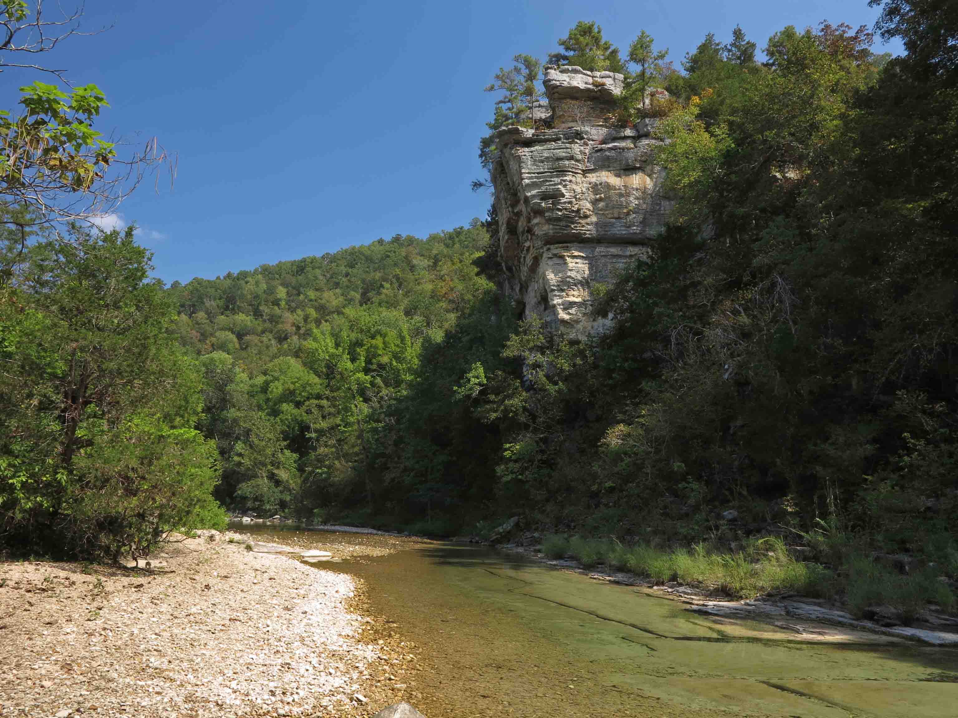
I was on the trail by 6:30 a.m. to beat the heat that was scheduled to overtake the day. From my first steps on the trail, it felt like I was getting reacquainted with an old friend. The crosstie steps and gradual climb to the bluffs over Sylamore Creek were a great morning wake-me-up and my first views down into the valley made the climb worthwhile.

North Sylamore Creek Valley
Arriving back down at creek level a few miles later provided a chance to walk on the limestone gravel shore and hear the china-like jingle as your feet sink a little into each step. The stained overhanging bluffs reminded me of the Buffalo River.

North Sylamore Creek
I was surprised to see a little friend swimming the clear creek water. He looked like one very happy snake.

I only encountered two groups of hikers between Blanchard Springs and Gunner Pool. I enjoyed visiting with a group of hikers from Memphis, who spent the night on the creek and were then hiking past Gunner Pool to Barkshed on down the trail. I was a little envious, but the heat kept me from feeling too bad about not following their itinerary.

This pedestal rock was posted down in a drainage about 0.5 mile from Gunner Pool. I look forward to revisiting this area in winter and getting a better view of the beautiful rock formations all along this 5-mile section of trail.

pedestal
Arriving at Gunner Pool was a surprise. I’d envisioned a wide spot in the creek, but this was a nice campground with pit toilets and several water stations. Gunner Pool was a haven for wildlife and plant life and sat above Sylamore Creek.

Gunner Pool
A small spillway encloses Gunner Pool and then flows on into Sylamore Creek below. This dam was built by the CCC Hedges Camp, active from 1933-42.

Gunner Pool spillway built by the CCC Camp Hedges 1933-42
After exploring Gunner Pool I headed back to Blanchard Springs, I took some time to explore the location where I remembered camping several years ago. On that particular night, I heard coyotes howl in the middle of the night. It was a musical treat. After that night, I’ve always looked forward to the possibility of coyote serenades whenever I camp in the Ozarks.
One puzzling sound from that night was a loud boom and splash in the creek. I thought to myself, “Boulders have to fall from those bluffs sometime, so how lucky that I got to hear one.” A few minutes later another boom and splash. I took my flashlight and explored upstream to learn more about the sound. Another boom and my light came to rest on a beaver swimming in the creek, occasionally flipping over and slapping the water with its tail. The falling rock mystery was solved.
The following morning I walked back into the woods and made my way to the point of the bluff pictured below. It was quite a view and a great place for morning coffee!
Bluff point on North Sylamore Creek
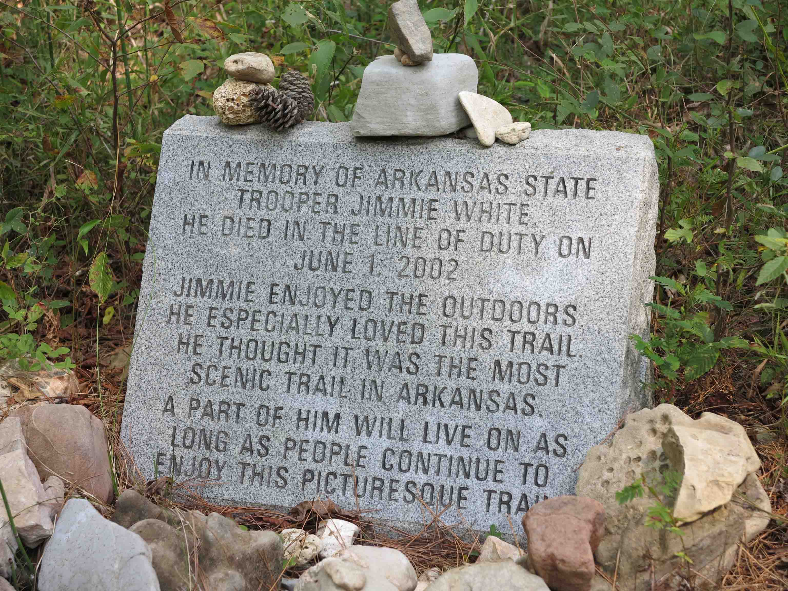
Memorial for Jimmie White, Arkansas State Trooper
I was interested to see this monument along side of the trail. I later read that Trooper White was killed on his motorcycle while working a motorcade escorting the Blue Angels pilots as they prepared for an air show in 2002. The stone said Trooper White especially loved this trail and thought it was the most scenic trail in Arkansas.
This out-and-back hike was about 11-miles in all. The sign says 4.5 miles from point to point, but I logged 5.4 miles one way. I was pleased to get reacquainted with this beautiful trail and look forward to a backpacking trip here in winter.

Nice hike…been wanting to get back up there myself…lack of loops in trail tends to keep me away but is a beautiful and unique area. Creek is so clear with that white gravel.
What were the conditions of the trail like? Any encounters with ticks, etc? I’m looking at making that hike in one day as well. If you began at 6:30am, what time did you finish back at Blanchard Springs? Thanks for your feedback.
The tick population seems to be healthy in the Ozarks but I didn’t see any on this hike. Some hikers I visited with encountered chiggers so bug spray is a good idea. I ended my hike around 1:00 p.m., but spent some time stopping for photos and exploring along the creek. Thanks for reading.
Hey, Jim. I was one of the hikers you met from Memphis. We thru-hiked the entire trail and I clocked it at 24.4 miles. Very hot, lots of sweat, bug spray is a must. Only a few ticks. Cool, clear water available the whole way, though. Most beautiful sections are Gunner Pool to Blanchard Springs and then Blanchard Springs to Allison. During winter leaf-off period the views are spectacular. I’m looking forward to your book…let me know when it’s published.
Great to hear from you, Paul. Thanks for making contact. Sounds like your group had a great trip. I’m looking forward to backpacking this section (in cooler weather). Will keep you posted on book progress. My final submission date is September, 2016, but I’m not sure when the publishing date will be. I’m learning a lot in the hiking and writing. Take care.
Hi all,
I have hiked several smaller sections of this trail before, but never a full thru-hike. I was actually there over this past weekend…we camped at Gunner Pool. We took a day hike on the trail east toward Blanchard Springs. Maybe 200 yards past the hollow with the rock pedestal “standing guard” we noticed what looked like an old dilapidated house down in the more level area of the hollow. We kept walking and just afterward the trail crossed an old logging road. Instead of following the trail markers uphill on the road, we followed the road downhill to get a better look at the house. After a 5 minute walk downhill, the road wound its way to the area of the house (or what is left of it). It was obviously quite old, but not one of the log homesteads you can still see in this area. Three of the four walls had collapsed along with the roof, it had faded white siding, and it was marked with some USGS signs. Based on its construction (framing, windows, roof shingles) I would guess this was built in the 1940-50’s. There is also an old upended oven/range inside that seems to be of that era. There is also a 30+ foot stone chimney and fireplace nearby. Just wondering if anyone has come across this or might know what the house was used for? It was interesting to come across this place and I’m just curious about its purpose.
Thanks and enjoy the trail…wherever that may be!
I do a lot of backpacking, but had not heard of this trail! I am going to add it to my list for the year! Thanks for sharing!